Modern surveying technology has transformed how we measure properties. Gone are the days when surveyors relied solely on tape measures and theodolites. Today's chartered surveyors use laser scanning technology that captures millions of measurement points in minutes, creating incredibly accurate representations of buildings and land. Let's explore this technology and why it matters for your property surveys.
What Is Laser Scanning?
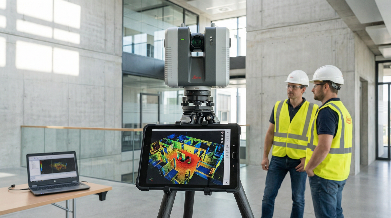
Laser scanning, also called 3D scanning or LiDAR (Light Detection and Ranging), uses laser beams to measure distances with extreme precision. A laser scanner emits pulses of laser light that bounce off surfaces and return to the scanner. By measuring how long each pulse takes to return, the scanner calculates the exact distance to every point it hits.
Modern scanners can capture hundreds of thousands of points per second, building up a detailed three-dimensional "point cloud" that represents the physical space. This point cloud data becomes the foundation for accurate measured surveys, lease plans, and boundary documentation.
How Laser Scanning Works in Property Surveys
When our team conducts a measured survey using laser scanning, we set up the scanner at strategic positions throughout the property. The scanner rotates 360 degrees, capturing data about every visible surface – walls, floors, ceilings, windows, doors, and architectural features.
For a typical residential property, we might set up the scanner in 5-10 positions to ensure complete coverage. For larger commercial properties, more scan positions are needed. Each scan overlaps with the next, allowing software to stitch them together into a complete model.
The entire scanning process for a standard three-bedroom house takes about 30-45 minutes. Compare this to traditional measuring methods that might take 3-4 hours, and you see why laser scanning is revolutionary.
Advantages of Laser Scanning Technology
Unmatched Accuracy
Laser scanners achieve millimeter-level accuracy. When you're creating Land Registry compliant lease plans or boundary plans, this precision matters. Traditional tape measures might be accurate to within a few millimeters if used carefully, but human error easily creeps in. Laser scanners eliminate most of that error.
For commercial properties where rent calculations depend on square footage, millimeter accuracy prevents disputes. For boundary plans where property lines must be precise, laser scanning provides definitive measurements that stand up to scrutiny.
Speed and Efficiency
Laser scanning dramatically reduces site visit time. What used to take half a day can now be completed in an hour. This efficiency benefits everyone – property owners don't need to provide access for as long, surveyors can handle more projects, and clients receive results faster.
The speed doesn't compromise quality. In fact, because scanning captures everything in the scanner's view, it often documents details that manual surveys might miss. That architectural detail in the ceiling, the exact curve of a bay window, the precise angle of a wall – all captured automatically.
Comprehensive Data Collection
Perhaps laser scanning's greatest advantage is completeness. Traditional surveys capture only the measurements the surveyor thinks are relevant. Laser scanning captures everything. Later, if you need additional information that wasn't in the original survey scope, it might already exist in the scan data.
We keep scan data archived for our clients. Years later, if you need additional measurements or a different type of plan, we can often generate it from the existing scans without revisiting the property.
Safety Benefits
Some properties present hazards – unstable structures, difficult access points, or dangerous areas. Laser scanning allows surveyors to capture data from safe positions. The scanner can measure features that might be dangerous or difficult to reach with traditional methods.
For industrial properties with heavy machinery, or commercial buildings under construction, the ability to scan from safe positions without physically measuring every element improves surveyor safety significantly.
Applications in Lease Plan Surveying
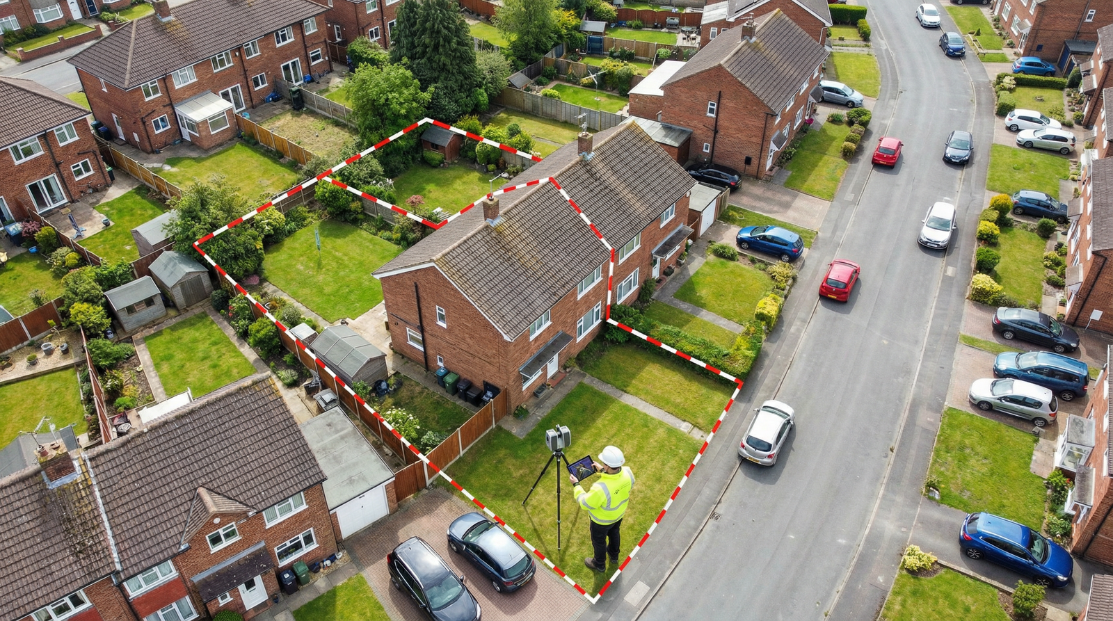
Boundary Accuracy
When creating lease plans, accurate boundary definition is crucial. Laser scanning captures the exact position of walls, fences, and other boundary features. This precision ensures your compliant lease plan shows boundaries accurately, meeting Land Registry requirements and preventing disputes.
Complex Layouts
Properties with irregular shapes, curved walls, or unusual architectural features challenge traditional measuring methods. Laser scanning handles complexity easily. Whether it's a period property with curved bay windows or a modern design with angular walls, the scanner captures every detail accurately.
Multi-Level Properties
For properties spanning multiple floors, laser scanning ensures floor plans align correctly. The scanner captures floor levels, ceiling heights, and the relationships between different levels precisely. This matters for commercial properties where different floors might be leased separately, or residential properties with complex split-level designs.
The Process: From Scan to Plan
Step 1: Site Scanning
Our chartered surveyors visit your property with professional laser scanning equipment. We set up at strategic positions, ensuring complete coverage. The scanning itself is relatively quick, though we also take photographs and notes about features that need special attention in the final plans.
Step 2: Data Processing
Back in the office, we process the scan data. Specialized software stitches the individual scans together, creating a complete 3D model of your property. We clean up the data, removing any scanning artifacts or irrelevant objects captured during scanning.
Step 3: Plan Creation
From the processed 3D data, we generate 2D plans showing floor layouts, elevations, and cross-sections as needed. For lease plans, we ensure all Land Registry requirements are met – proper scale, north point, clear boundaries, and all relevant features accurately positioned.
Step 4: Quality Control
Before delivering plans to clients, we conduct thorough quality checks. We verify measurements, ensure nothing was missed, and confirm the plans match the scan data accurately. This quality control is why our lease plans have a 98% first-time acceptance rate with the Land Registry.
Laser Scanning vs. Traditional Methods
Traditional surveying methods still have their place, particularly for certain types of work. However, for measured surveys and lease plan production, laser scanning offers significant advantages:
Accuracy: Millimeter precision vs. centimeter precision of manual methods
Speed: Minutes to scan vs. hours to measure manually
Completeness: Captures everything vs. selective manual measurements
Verification: Data can be re-checked vs. requiring site revisits
Detail: Captures architectural complexity easily vs. challenging manual measurements
Many professional surveyors now use hybrid approaches, combining laser scanning for overall accuracy with traditional methods for specific details or verification.
Cost Considerations
You might expect laser scanning to cost more than traditional surveys. However, because it's faster and more efficient, laser-scanned surveys often cost about the same or only slightly more than traditional surveys.
The value proposition is clear: you get better accuracy, faster turnaround, and more comprehensive data for similar cost. For commercial properties where accuracy matters for rent calculations, or properties with complex layouts, laser scanning often saves money by preventing disputes and rework.
The Future of Property Surveying
Laser scanning technology continues to advance. Newer scanners are lighter, faster, and more accurate. Mobile scanning systems allow surveyors to walk through properties while scanning continuously. Drone-mounted scanners capture exterior and roof details safely from the air.
Integration with Building Information Modeling (BIM) software means scan data feeds directly into architectural and engineering workflows. For property developers and facilities managers, this integration streamlines project planning and building management.
Artificial intelligence is beginning to assist in scan processing, automatically identifying features and generating plans more quickly. While human expertise remains essential for quality control and meeting specific requirements, AI tools make the process even more efficient.
Choosing a Surveyor with Laser Scanning Technology
Not all surveyors use laser scanning. When choosing a surveyor for measured surveys or lease plans, ask about their technology. Key questions include:
- What scanning equipment do they use?
- How experienced are they with laser scanning?
- Do they keep archived scan data?
- What accuracy do they achieve?
- Can they provide examples of previous scan-based projects?
Professional accreditation matters too. Our team holds RICS, CIOB, and RPSA qualifications, demonstrating we meet professional standards for surveying technology use and data quality.
Conclusion
Laser scanning technology has revolutionized property surveying, enabling unprecedented accuracy, speed, and comprehensiveness. For clients needing lease plans, measured surveys, or boundary documentation, this technology delivers superior results compared to traditional methods.
Whether you're a property owner, developer, landlord, or buyer, choosing surveyors who use modern laser scanning technology ensures you receive accurate, reliable documentation that meets professional standards and Land Registry requirements.
If you need a measured survey or lease plan for your property, get in touch with our experienced team. We use professional laser scanning equipment on every project, ensuring accuracy and quality you can trust.
Experience Modern Surveying Technology
Our chartered surveyors use professional laser scanning equipment for superior accuracy and faster turnaround. Get the benefits of cutting-edge surveying technology.
Request a Measured Survey